Where Water Comes From
Water Cycle
Water is always in motion, constantly evaporating from oceans, lakes, rivers and puddles, condensing into the atmosphere and falling back down to the ground in the form of precipitation. This process, known as the water cycle, not only replenishes our environment but also sustains all living things.
This natural cycle can be summarized as the continuous movement of water on, above or below the Earth’s surface. The cycle is divided into several important phases – evaporation, precipitation and transpiration. Each step holds equal importance in the replenishment of Long Island’s public drinking water supply, which comes from aquifers located deep within the earth.
Every day, water from lakes and oceans evaporates and is then absorbed into clouds. When the clouds reach full capacity, they condense the liquid and release it in the form of precipitation such as rain, snow and hail. After it falls to the ground, the majority of this liquid penetrates the earth, trickling through the surface and eventually collects in one of Long Island’s aquifers.
As the water passes through the earth, the sand and soil act as a filter and naturally cleanse the water before it replenishes the aquifers.
Underground Source
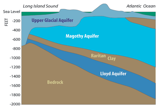
Long Island’s sole source of water has a very interesting past and present. To understand how Westbury residents enjoy such clean and purely delicious drinking water, one must understand the sole source of water – aquifers.
An aquifer is an underground geological formation composed of sand, gravel or rock and is capable of storing large quantities of groundwater. These natural storage tanks are tapped into by utilities located throughout the region including the Westbury Water District.
All of Long Island’s public water supply is stored in three aquifers, all of which possess different yet vital roles in the preservation of nature’s most precious resource.
Approximately 10 million years ago, the glacial sands and gravel that make up Long Island formed to generate one large unenclosed aquifer. Today, this aquifer is known as the Upper Glacial Layer. Since the water that resides in this layer consists of precipitation that fell between the last 10 to 50 years, it is not utilized as drinking water for the public.
The region’s most important source of drinking water is the Magothy Aquifer. Located just below the Upper Glacial Layer, this aquifer is the largest formation, reaching as deep as 200 to 1,000 feet below the earth’s surface. It is composed mainly of sand, gravel and silt and contains water that has trickled down from the Upper Glacial Layer.
Just underneath the Magothy Aquifer is the Raritan Clay Layer. This layer is quite thick, about 100 – 200 feet, and sits between the Magothy and Lloyd Aquifers.
The deepest and oldest aquifer is the Lloyd Aquifer. Mostly untapped, it is situated more than 200 feet below the earth’s surface and may contain water that is more than 5,000 years old. The Lloyd Aquifer provides tap water to a small amount of towns on Long Island, including Long Beach, Lido Beach and Point Lookout.